all data refer to year 2000
| Off the beaten track |
| France - A survey about petroglyphs in the Alps all data refer to year 2000 |
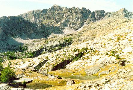
The engraved area I am talking about is around the Mount Bego and the region covers both the two
valleys known as Vallee des Merveilles and Fontanalbe.
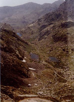 Both are in the Marittime Alps, between the two villages of Saint Dalmas de Tende and
Tende in the South East of France.
Both are in the Marittime Alps, between the two villages of Saint Dalmas de Tende and
Tende in the South East of France.
Since I was a child my father took me there very often during Summer holidays in order to make me know
and appreciate the places he was born and lived in.
More late I started to do the same, taking people there to discover natural beauties and ancient relics.
I visited about fifteen times the places I am going to talk about and each time landscapes and savage
nature left me astonished as it was the first time.
[Click here to get the simple route plan to reach the Park].
All the engraved area is now inside the National Park of Mercantour and the access is limited
in order to preserve such kind of ancient relics.
I'd like to give you some information on how to contact the responsibles of the two main shelters
and the Park Management Office where you can find the details about the severe rules that regulates
the access to the Mercantour National Park.
Remember: in France, rules have to be respected!
[click here to get the map of limited access area].
The Vallee des Merveilles is so called because there are a lot of lakes, rocks
of various color, trees and flowers, and thousand of engraved figures.
 The place was well known by people who lived there and around and my grandfather
told me about the work made to catalog the figures. Just staring from 1927 up
to 1942 Carlo Conti was charged by the Archaeological Superintendance of Piedmont
(The valley was Italian before 1947) to study the rocks. He catalogued about 35000
figures and also dug in the shelter that locals called Gias del Ciari
(Shelter of the Mouse) and there he found pottery from Cardial Neolithic to early
Bronze Age and some small silex blades.
The place was well known by people who lived there and around and my grandfather
told me about the work made to catalog the figures. Just staring from 1927 up
to 1942 Carlo Conti was charged by the Archaeological Superintendance of Piedmont
(The valley was Italian before 1947) to study the rocks. He catalogued about 35000
figures and also dug in the shelter that locals called Gias del Ciari
(Shelter of the Mouse) and there he found pottery from Cardial Neolithic to early
Bronze Age and some small silex blades.
He thus divided the region into 21 zones, using Roman notation (I-XXI).
The C letters and the roman numbers engraved near the signs are witnesses
of the work did by the Italian archeologist.
It is possible to find both prehistoric and historic engravings as well as
pecked engravings and linear engravings. Pecked one are mostly prehistoric
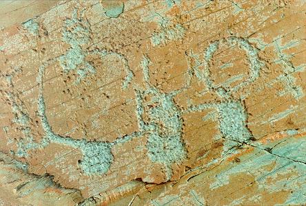 while linear one, easily made by a metal point, are mostly historic.
It is often claimed that the high concentration of engarved rocks was due to
the presence of two open air sanctuaries or sacred mountains (as written in
the small guide on the rear of the map).
while linear one, easily made by a metal point, are mostly historic.
It is often claimed that the high concentration of engarved rocks was due to
the presence of two open air sanctuaries or sacred mountains (as written in
the small guide on the rear of the map).
Although many places was chosen by prehistoric people because full of religious
meanings, another fact to take in account is that those sandstone rocks are not
exfoliated, perfectly polished by the glacier and not too hard to engrave. So is
not sure that the area was a kind of sanctuary as supposed by some people.
Since three figures of high interest was found the Vallee des Merveilles has
been divided in three regions: The rock of the Shaman, the Rock of the Chief and
the Rock of Christ... This last one is a strange figure engraved in quite recent:
the subject is a face that seems like the Christ one.
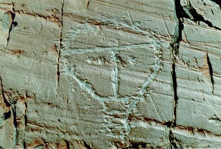
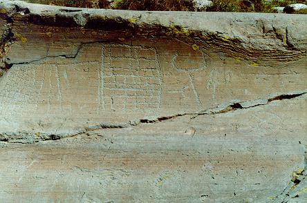
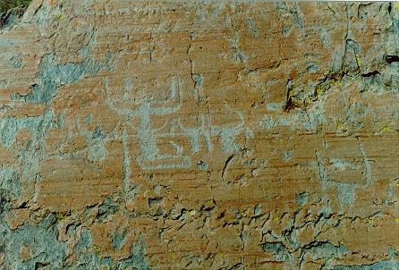
The main typologies of pecked prehistoric engravings are three: horned figures,
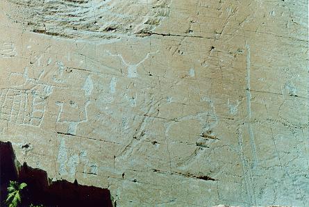
weapons (some daggers and halberds), grid figures (supposed to be square grids and topographic figures such as field and so on.
Prehistoric figures has been dated to the ancient Bronze Age (1800-1500 bC)
because it is possible to recognize the shapes of Bronze Age daggers and halberds engraved on the rocks.
It is also possible to find few Copper Age axes, while most of the so called
topographic engravings must be dated up to the first Chalcolithic period
or to the late Neolithic, as demonstrated by a comparison with the identical
figures in Valcamonica.
It is possible to say that the prehistoric period of Bego's site pecked
engravings range from the late Neolithic to the Ancient Bronze Age, excluding
the Iron Age, represented by the engravings in Valcamonica. Infact during the
Iron Age the climate was supposed to be colder and people did not live in the
area of Mount Bego and thus was not able to make engravings.
The themes of the engravings can be divided in two main categories: soil
related figures such as topographic figures, cattle, plows)
and weapons related figures (knives, daggers and halberds).
Soil related figures seem to be the older ones, often superimposed by daggers.
There was perhaps the influence of pastoral activity, but there was also perhaps a ritual intention in engraving a figure for cultural evidence or to bring good luck for the harvest.
 |
Hunt scene A kind of totem Horned figures |